


Geological and Comprehensive Mineral Exploration Services
Unleashing the Earth's Hidden Treasures
Your trusted partner for cutting-edge Geological, Hydro-geological, and Comprehensive Mineral Exploration Services. Our team of geologists, hydrologists, and exploration experts is dedicated to uncovering the Earth's hidden treasures, providing you with invaluable insights for successful mineral exploration and resource development projects.
Our Geological and Comprehensive Mineral Exploration Services Include -
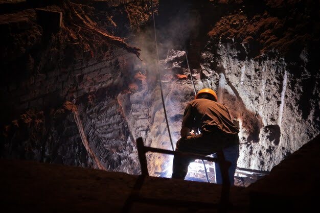
Geological Surveys and Mapping: Benefit from our detailed geological surveys and mapping services. We analyze geological formations, rock structures, and mineral occurrences to identify promising exploration targets and potential resource deposits.
Hydro-geological Studies: Understand the intricate relationship between groundwater and geological formations through our hydro-geological studies. We assess aquifer characteristics, water quality, and groundwater potential to support sustainable water resource management.
Mineral Exploration Planning: Plan your mineral exploration projects with precision. Our experts help you develop comprehensive exploration strategies, considering factors such as geology, mineralogy, and regional tectonics.
Geophysical Surveys: Utilize cutting-edge geophysical surveys to explore beneath the Earth’s surface. We employ advanced techniques like magnetic, electromagnetic, and gravity surveys to detect subsurface anomalies indicative of mineral deposits.
Remote Sensing and Satellite Imagery Interpretation: Harness the power of remote sensing and satellite imagery to identify potential mineral deposits and geological features over large areas, streamlining the exploration process.
Data Analysis and Resource Estimation: Rely on our expertise in data analysis and resource estimation. We employ statistical methods and geological modeling to estimate mineral resources accurately and assess their economic viability.
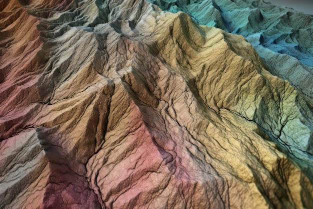
Geomorphological Studies: Delve into the fascinating world of landforms with our geomorphological studies. We analyze the origin, evolution, and characteristics of various landscapes, providing crucial information for land use planning, environmental assessments, and geological exploration.
Terrain Analysis: Gain a comprehensive understanding of terrain characteristics through advanced terrain analysis. Our experts evaluate slope, aspect, curvature, and other terrain attributes to assess erosion risks, land stability, and potential geological hazards.
Geomorphic Change Detection: Monitor changes in landscapes over time with our geomorphic change detection services. We utilize remote sensing and geospatial analysis to identify areas prone to erosion, deposition, or other geomorphic transformations.
Lineament Mapping and Analysis: Identify geological features and structural lineaments with our specialized lineament mapping and analysis services. These lineaments provide valuable clues about subsurface geological structures and potential mineralization zones.
Geological Hazard Assessment: Assess the risk of geological hazards, such as landslides, earthquakes, and volcanic activity, through a combination of geomorphological analysis and geological data interpretation.
Geomorphological Mapping for Infrastructure Projects: Ensure the success of infrastructure projects by conducting geomorphological mapping to identify potential challenges and recommend suitable construction approaches.
Industries We Serve
Embark on a journey to understand the Earth’s sculptors with MB Analytics Pvt. Ltd.’s Geomorphology and Lineament Mapping Services. Contact us today to explore how our expertise can enrich your geological, environmental, and engineering endeavors.
Industries We Serve:
Geological Exploration and Mining: Utilize geomorphological insights and lineament mapping to identify potential mineral and ore deposits, optimizing exploration efforts.
Civil Engineering and Construction: Ensure the safety and stability of infrastructure projects by incorporating geomorphological considerations in design and planning.
Environmental and Natural Resource Management: Make informed decisions regarding land use, conservation, and sustainable resource management based on geomorphological assessments.
Geohazard Mitigation and Disaster Management: Employ geomorphological studies to assess and mitigate geological hazards, reducing the risk to communities and infrastructure.